Maps
Getting Oriented
When I bought my ticket I had no idea of where it was exactly I was going to be walking beyond Northwest Spain. The following shows where I was in Spain and how far I walked each day.
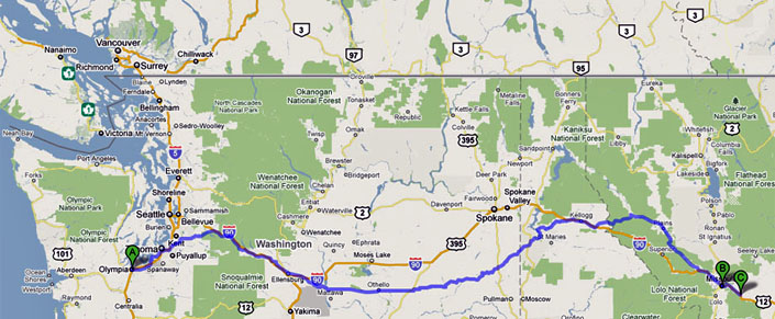
The distance I walked roughly compares to starting at my home in Olympia, Washington and walking a bit further than Missoula, Montana.
I’m glad I didn’t look at it like this before I went, because 500 miles seemed doable, but Olympia to Missoula seems like a very long way. Each day, I only walked as far as I felt like walking. I usually started with a goal of roughly 20km, but would stop sooner or go further depending on how I felt. I was most concerned at how I would do carrying a 20 lb pack going up and down steepish inclines. (That proved to be doable too) . The distance yet to go never loomed over me.
I also discovered that the route I was walking was only the one most commonly used by pilgrims starting in Europe. It is called the Camino francés. While many Spanish people choose to start in Roncevalles (and even more in the city of Sarria, just over a hundred kilometers from Santiago) other Spaniards choose to just walk from their front doors and follow other historical routes through central Spain. The map below is from the Spanish credential and shows the major routes inside of Spain.

Starting in Le Puy is very popular among the French who often walk two weeks a year as far as they can, and return the next year to begin where they left off. Some, like Michel, did it all in one go, walking nearly 3 months in all. Though not shown on the map, starting in Portugal, especially Porto is also gaining in popularity.

The map below shows the regions the Camino francés passes through: Navarra, La Rioja, Castilla y Leon, Galicia, and their physical relationship to the rest of the county.
- Autonomous regions of Spain
The route goes over mountains, and across the high, wide plains known as the meseta, then down to the sea. This graph shows elevation changes. Click on the chart to get a clearer view.


I love your website, your thoughts, and all of your wonderful imagery. It is incredible how much the same, yet how different each of our Caminos are. Thank you for sharing your journey.
What a wonderful site to discover – love your maps! Also, we are practically neighbors as I live just north of you in Edmonds. Am planning to walk the Camino this September. I must admit that when you said ‘Olympia to Missoula’, my heart skipped a beat!
Have a great time… let me know if you will be blogging you walk, I’d love to follow you. You might enjoy the being in contact before you go or after you come back with the Seattle Chapter of American Pilgrims on Camino. They do 10k walks every 2nd Sunday of the month starting at 1:15 meeting at the entrance to Ballard Locks